Distance from Shirley to Redditch
Distance between Shirley and Redditch is 14 kilometers (9 miles).
Driving distance from Shirley to Redditch is 21 kilometers (13 miles).
Distance Map Between Shirley and Redditch
Shirley, London, United Kingdom ↔ Redditch, London, United Kingdom = 9 miles = 14 km.
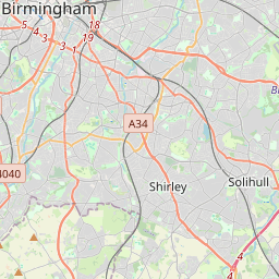


How far is it between Shirley and Redditch
Shirley is located in United Kingdom with (52.4107,-1.8195) coordinates and Redditch is located in United Kingdom with (52.3065,-1.9457) coordinates. The calculated flying distance from Shirley to Redditch is equal to 9 miles which is equal to 14 km.
If you want to go by car, the driving distance between Shirley and Redditch is 21.29 km. If you ride your car with an average speed of 112 kilometers/hour (70 miles/h), travel time will be 00 hours 11 minutes. Please check the avg. speed travel time table on the right for various options.
Difference between fly and go by a car is 7 km.
| City/Place | Latitude and Longitude | GPS Coordinates |
|---|---|---|
| Shirley | 52.4107, -1.8195 | 52° 24´ 38.6640'' N 1° 49´ 10.2720'' W |
| Redditch | 52.3065, -1.9457 | 52° 18´ 23.4000'' N 1° 56´ 44.4840'' W |
Estimated Travel Time Between Shirley and Redditch
| Average Speed | Travel Time |
|---|---|
| 30 mph (48 km/h) | 00 hours 26 minutes |
| 40 mph (64 km/h) | 00 hours 19 minutes |
| 50 mph (80 km/h) | 00 hours 15 minutes |
| 60 mph (97 km/h) | 00 hours 13 minutes |
| 70 mph (112 km/h) | 00 hours 11 minutes |
| 75 mph (120 km/h) | 00 hours 10 minutes |
Related Distances from Shirley
| Cities | Distance |
|---|---|
| Shirley to Birmingham | 14 km |
| Shirley to Southampton | 205 km |
| Shirley to Leicester | 69 km |
| Shirley to Manchester | 167 km |
| Shirley to Dudley | 51 km |
Related Distances to Redditch
| Cities | Distance |
|---|---|
| Birmingham to Redditch | 26 km |
| City Of London to Redditch | 188 km |
| Manchester to Redditch | 162 km |
| Oxford to Redditch | 109 km |
| Coventry to Redditch | 55 km |